Hurricane Isaias was on the cusp of major hurricane strength Friday morning, with maximum sustained winds of 110 mph at 7 a.m. Central, about 245 miles south of Pensacola, Florida, and moving north-northeast at 15 mph. Data from an Air Force Reserve Hurricane Hunter aircraft showed a central pressure of 958 millibars. The National Hurricane Center said Isaias is likely to become a major hurricane that morning. A hurricane becomes major at Category 3, which starts at 111 mph, and Fox Weather has reported Category 3 strength with 120 mph winds.
Isaias on the Cusp of Category 3 as Gulf Coast Braces
The National Hurricane Center expects landfall tonight or early Saturday within a hurricane warning area from Mississippi to the Florida Panhandle.
By Lynn Matthews - October 9, 2026
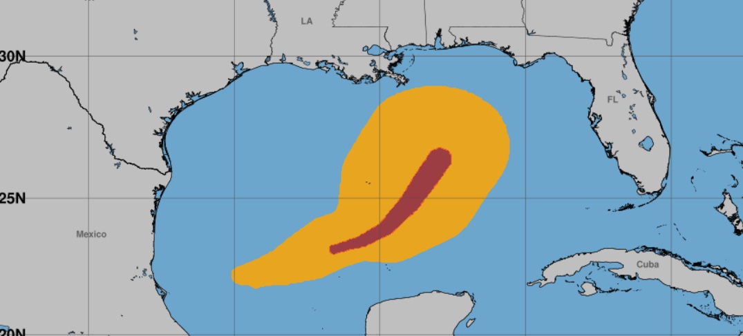
On its forecast track, the storm will approach the northern Gulf Coast Friday afternoon and make landfall within the hurricane warning area tonight or early Saturday. The hurricane center said Isaias should remain a dangerous hurricane at landfall. Reports citing forecasters say they expect a high-end Category 2 at landfall, though a delay in wind shear could allow a stronger storm. Hurricane-force winds extend up to 30 miles from the center, and tropical-storm-force winds extend up to 185 miles.
The hurricane center's corrected surge forecast calls for 6 to 9 feet from the Alabama-Florida border to Grayton Beach, if the peak surge arrives at high tide. Forecasts call for 4 to 6 feet from Dauphin Island to the Alabama-Florida border and 4 to 7 feet from Grayton Beach to Indian Pass, Florida. Mobile Bay and the coast from the mouth of the Mississippi River to Dauphin Island could see 3 to 5 feet.
A hurricane warning covers the coast from Ocean Springs, Mississippi, to the Bay/Gulf County line in Florida. A storm surge warning runs from the mouth of the Mississippi River to the Suwannee River. A tropical storm warning covers the Jefferson/Plaquemines Parish line in Louisiana to west of Ocean Springs, along with the Florida coast east of the Bay/Gulf County line to the Aucilla River. Mandatory evacuations are in place for Dauphin Island, Alabama, and for Okaloosa, Escambia and Walton counties in Florida.
Rainfall of 4 to 8 inches is expected across southern Alabama, the Florida Panhandle and Big Bend, and southwest Georgia, with local totals up to 15 inches. The hurricane center said flash flooding is likely and impacts could be considerable across much of southern Alabama. A tornado risk begins late Friday afternoon and continues tonight in coastal Alabama, the Florida Panhandle and far southwest Georgia.
Farther inland, gusts of 50 to 60 mph or higher are possible in Central Alabama from Friday evening into Saturday, with the worst conditions around midnight. Widespread power outages are possible far from where the storm comes ashore. Offshore, Shell and Chevron have shut in production at five facilities. Residents in evacuation zones should follow the instructions of local officials. The next complete hurricane center advisory is due at 10 a.m. Central.
Sources:
Topics:Hurricane Isaias landfallIsaiasHurricaine IsaiasCat3Hurricane Isaias Isaias landfall Isaias Alabama Gulf Coast hurricane Category 3 hurricane storm surge hurricane warning Florida Panhandle Mobile Bay Dauphin Island hurricane evacuation National Hurricane Center
Have a correction or tip? See our corrections policy or contact the newsroom.
Comments
to join the discussion.
Loading comments...